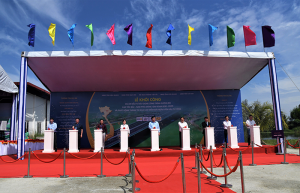
Groundbreaking Ceremony taken place at Ca Mau province
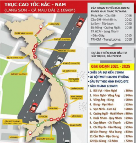
The Eastern North – South expressway construction project, period 2021 – 2025 is included in the Vietnam expressway planning approved at Resolution No. 44/2022/QH15 dated 11/01/2021, of which Hau Giang – Ca Mau expressway is one component. The Minister of Natural Resources and Environment issued Decision No. 1135/QD-BTNMT dated 31/5/2022 approving the appraisal of the Environmental Impact Assessment Report of Hau Giang – Ca Mau component under Eastern North – South expressway construction project, period 2021 – 2025. The Ministry of Transport issued Decision No. 912/QD-BGTVT dated 13/7/2022 approving of Hau Giang – Ca Mau component under Eastern North – South expressway construction project, period 2021 – 2025.
Figure 1. Eastern North – South expresswawy construction project, period 2021-2025
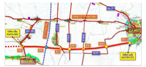
Figure 2. Hau Giang – Ca Mau expressway alignment.
Location: Hau Giang – Ca Mau expressway project component is in the provinces of Hau Giang, Bac Lieu, Kien Giang and Ca Mau.
The starting point of Hau Giang – Ca Mau expressway at Km53+000 is the ending point of Can Tho – Hau Giang project component. The ending point of Hau Giang – Ca Mau expressway at Km126+223 intersects with the Southern coastal corridor in Thoi Binh district, Ca Mau province (about Km210+250 of the Southern coastal corridor). The length of the route is approximately 73.223km (the section passing Hau Giang province is 26.61km; the section passing Bac Lieu province is 7.7km; the section passing Kien Giang province is 17.04km; the section passing Ca Mau province is 21.873m).
Connecting road: The starting point at Km0+000 connects with the ending point of Hau Giang – Ca Mau project component (Interchange IC12) in Thoi Binh district, Ca Mau province. The ending point at Km16+597 connects with NH.1 in Cai Nuoc district, Ca Mau province. The total length of the route is about 16.597km.
Area of the package:
– Starting point: at Km91+800 in Vinh Thuan district, Kien Giang province. This is the point connecting with the ending point of Package XL-01.
– Ending point: at Km114+200 in Tan Phu commune, Thoi Binh district, Ca Mau district. This point borders Package XL-03.
Length of Package XL-02: 22.4 Km
Scale and technical specifications of main works of the project:
– Expressway: It is designed to be expressway grade 100 in the complete phase with design velocity V = 100 km/h according to Standard coded TCVN 5729:2012. The expressway will have 4 motorized lanes and width of embankment B = 24.75m.
– In phase 1, the geometric elements (layout plan, longitudinal profile) fulfills standards for expressway grade 100. The expressway will have 4 motorized lanes in accordance with Standard TCCS 42:2022/TCDBVN “Expressway – Design and traffic management in the phase of stage construction”. The scale of 4 motorized lanes is limited, and the width of embankment is B = 17m. The operation velocity V = 80km/h.
– Connecting road: Plain road class III, design velocity V = 80km/h.
– Crossing road: Plain road class III and IV according to Standard TCVN 4054:2005.
– Frontage road: Rural road class B according to Standard TCVN 10380 – 2014.
– Bridge construction:
+ Scale: Bridges will be constructed permanently with RC and pre-stressed RC;
+ Design load: HL93 according to Standard TCVN11823-1:2017 and Standard TCVN11823-14:2017.
+ Width of bridges on expressway: The width of bridges is in accordance with the width of embankment. In phase 1, the width of bridges is B = 17.5m. In complete phase, a new module will be added nearby with breadth B = 16.25m.
VNCN E&C is implementing the section from Km98+740 to Km110+485, ramp N7, Kenh Xang Huyen Su bridge and Kenh Chuoi bridge.
Photo: The contract signing ceremony between PMU My Thuan and JV Contractor of Package XL-02 Hau Giang – Ca Mau component
 Tiếng Việt
 English


